- Michael McHugh
- All Artworks
- The Quiraing - Ise of Skye
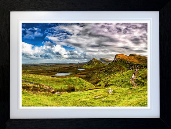
The Quiraing - Ise of Skye (2021) Photograph by Michael McHugh
62.7 x 47 x 2cm (framed) / 45.5 x 30cm (actual image size)
£310
Artwork description
The Quiraing (Scottish Gaelic: A' Chuith-Raing) is a landslip on the eastern face of Meall na Suiramach, the northernmost summit of the Trotternish on the Isle of Skye, Scotland. The whole of the Trotternish Ridge escarpment was formed by a great series of landslips; the Quiraing is the only part of the slip still moving – the road at its base, near Flodigarry, requires repairs each year.
Parts of the distinctive landscape have earned particular names. The Needle is a jagged 120-foot-high (37 m) landmark pinnacle, a remnant of landslipping. Northwest of it is The Table, a flat grassy area slipped down from the summit plateau, with vistas of the Torridon Hills and the mountains of Wester Ross. Southwest is the Prison, a pyramidal rocky peak which can look like a medieval keep when viewed from the right angle – the ascent of this is an airy scramble.
The name Quiraing comes from Old Norse Kví Rand, which means 'Round Fold'. Within the fold is The Table, an elevated plateau hidden amongst the pillars. It is said that the fold was used to conceal cattle from Viking raiders.
Materials used:
Baryta 300gsm Archival paper, Solid Wood frame, Archival Double Mount, anti reflective clear acrylic
Details:
- Photograph on Paper
- From a limited edition of 10
- Size: 62.7 x 47 x 2cm (framed) / 45.5 x 30cm (actual image size)
- Framed and ready to hang
- Signed and numbered certificate of authenticity
- Style: Photorealistic
- Subject: Landscapes, sea and sky
14 day money back guaranteeLearn more
Artwork description
The Quiraing (Scottish Gaelic: A' Chuith-Raing) is a landslip on the eastern face of Meall na Suiramach, the northernmost summit of the Trotternish on the Isle of Skye, Scotland. The whole of the Trotternish Ridge escarpment was formed by a great series of landslips; the Quiraing is the only part of the slip still moving – the road at its base, near Flodigarry, requires repairs each year.
Parts of the distinctive landscape have earned particular names. The Needle is a jagged 120-foot-high (37 m) landmark pinnacle, a remnant of landslipping. Northwest of it is The Table, a flat grassy area slipped down from the summit plateau, with vistas of the Torridon Hills and the mountains of Wester Ross. Southwest is the Prison, a pyramidal rocky peak which can look like a medieval keep when viewed from the right angle – the ascent of this is an airy scramble.
The name Quiraing comes from Old Norse Kví Rand, which means 'Round Fold'. Within the fold is The Table, an elevated plateau hidden amongst the pillars. It is said that the fold was used to conceal cattle from Viking raiders.
Materials used:
Baryta 300gsm Archival paper, Solid Wood frame, Archival Double Mount, anti reflective clear acrylic
Details:
- Photograph on Paper
- From a limited edition of 10
- Size: 62.7 x 47 x 2cm (framed) / 45.5 x 30cm (actual image size)
- Framed and ready to hang
- Signed and numbered certificate of authenticity
- Style: Photorealistic
- Subject: Landscapes, sea and sky